|
«MARINE PROTECTED NATURAL AREAS»
UNIQUE SCIENTIFIC REFERENCE AREAS ON THE HIGH SEAS
Hjalmar Thiel, University of Hamburg
Manuscript prepared for the symposium on УAktuele Probleme
der MeeresumweltФ held by the Bundesamt fuer Seeschifffahrt und Hydrography,
in Hamburg, Germany, on June 6Ч7, 2001
Arguments for the protection of selected areas are generally based on endangered
species, reduced biodiversity or disturbed communities. The contributions presented
during this workshop on fish (Fonteneau, Gordon), deep-water corals (Grehan),
birds (Johnston), mammals (Donovan), seamount communities (Koslow)
and hydrothermal vent communities (Juniper) all fall into these categories.
It is important to note that various high seas fisheries are the essential disturbing
agents except for the vent communities.
However, additional arguments exist for the creating protected areas. Those
areas may be termed collectively "monitoring and science areas". Their common
purpose is their availability for long-term research activities.
Stable Reference or Monitoring Areas
The concept of Stable Reference Areas (SRA) was first suggested during an IUCN
conference in Ashkhabad in 1978, and it was further discussed by the Ocean Policy
Board of the National Research Council of the US National Academy of Sciences
(NRC, 1984). These discussions were prompted by the development of polymetallic
nodule deep sea mining; it was concluded that two categories of SARs should
be established:
- the Preservational Reference Area (PRA) to serve as a reference area for the natural community development in undisturbed regions, and
- the Impact Reference Area (IRA) to monitor community development after severe disturbance by polymetallic nodule mining.
Both areas must be of sufficient size for a monitoring program lasting about
two decades. Ecologically they must be similar to mining areas in the wider
vicinity; this pertains to physical, sedimentological and topographical characteristics,
and also to the seafloor dwelling community. The PRA should be undisturbed by
all mining activities, and this is the same for the IRA following the primary
disturbance by mining.
For the last two decades the SRAs have been rather dormant since industrial nations have stopped developing deep-sea mining. They have not been forgotten, however, and now and then they re-appear in discussions. The concept of SRAs and the need to establish them are known to the International Seabed Authority. But the development of the mining code was restricted in its first phase to exploration activities of polymetallic nodule mining; the code for commercial mining will be considered only in the future. This must include discussions on PRAs and IRAs, where they should decide to what extent the scientific and monitoring activities are to be conducted by the mining contractors. The number of SRAs is still in ongoing debate. One PRA and IRA each should be established in or close to the Indian and the German mining claims in the central Indian Ocean and in the Peru Basin in the Southeast Pacific Ocean. In the North Pacific Ocean, where most of the claims are lined up in the Clarion Clipperton Fracture Zone, four PRAs and four IRAs would likely be sufficient.
SRAs can and will be established through regulations by the International Seabed
Authority, having the responsibilities for environmental protection of the Area
in relation to seabed mining. The establishment of preservational areas outside
the mining claims needs special regulations to result in internationally accepted
protection measures.
Unique Science Priority Areas (USPAs)
Effective and potential uses of the deep sea, particularly in the Area, have
been developed during the second half of the last century. Dumping of low level
radioactive wastes, sewage sludge and redundant munitions occurred, and final
storage of waste products (e. g. carbon dioxide) have been discussed. No ethical
argument can be brought forward for land storage versus deep-sea disposal, and
a weighted ecological evaluation may argue for using the resource deep-sea space
one day, although regulations like the London (Dumping) Convention exist (comp.
Thiel et al., 1998).
A decision for an area where ocean disposal should be conducted, would be based on ecological arguments and the transport of dissolved waste products with the predominant currents. Economic considerations will be of importance in such decisions to limit the costs of these actions. Some regions of the Area are certainly not suitable for waste disposal, and these are the localities of hydrothermal vents, seamounts and e. g. fish spawning grounds.
However, I would like to introduce arguments for reserved regions independent
from species, habitat or community safeguarding: the reservation of deep-sea
science priority areas. Deep-sea research has made great strides in the last
50 years; it has progressed from descriptive to process and modeling studies.
Earlier investigations concentrated on the near-continent and mostly continental
slope and rise regions, but in the last 20 years central oceanic habitats have
been include and, more importantly, long-term studies have been conducted to
understand the natural processes of production and its variability within and
between years. Researchers from Great Britain have studied repeatedly the occurrence
of organisms and the sedimentation of food resources in the region of the Porcupine
Seabight (Rice et al., 1991), a wide indentation of the continental shelf
in southwest Ireland, and another long-term program was conducted in the area
of the Rockall Trough to the west of Ireland and Scotland (Mauchline, 1986).
The research done by scientists from various European nations at a deep position
in the Porcupine Abyssal Plain was funded by the European Community through
several subsequent contracts (see Thiel and Rice, 1995).
During the 1980s and the 1990s German activities concentrated some 500 nautical
miles southwest of Ireland around a central position of 47░N and 20░W. Physical
and sedimentological investigations were related to the questions of radioactive
waste disposal (Mittelstaedt, 1986), and ecological studies concentrated
on the abundance and distribution of organisms, on seasonally pulsed organic
matter and energy income and dissipation, on turnover and production processes
(Thiel et al., 1989, Pfannkuche et al., 1995). The German Ministry of
Education and Research and also the German Research Council funded together
25 cruises or cruise legs with various research ships to this field. When the
international Joint Global Ocean Flux Study (JGOFS) developed in the late 80s,
the 47░N, 20░W position became the central locality for many international studies,
to supplement existing knowledge with ecological results elaborated in the water
column above the seafloor regions of the area of the former activities.
These various deep-sea research projects by European scientists Ц others exist,
e. g. By French colleagues in the Golf de Gascogne (Laubier and Monniot,
1985) and in the Pacific Ocean Ц have created a broad knowledge and understanding
of deep-sea ecological processes. These studies must be continued whenever new
questions arise or global change monitoring becomes an important issue. The
complementary scientific results from these regions should be get high marks
from the public. ItТs not only that a lot of money has been invested in this
research, but a valuable data base, important for later comparative studies,
has been created. If waste products were to be disposed of in one or more of
these scientific high intensity areas, the loss for later comparisons of data
would be tremendous. Such long-term reference stations might be never re-established.
In the interest of society we must do everything to protect these long-term
study areas for research by future generations.
Proposal for a Unique Scientific Priority Area
The central positions of various long-term research programs in the Northeast
Atlantic are presented in Figure 1. Three of them constitute a rather straight
line, earlier called the European Deep-sea Transect. These three areas should
come under protection, and a buffer zone of 100 nautical miles (nm) around their
central position should mark them. However, it would be more convenient to define
their borders in the form of a rectangle. Therefore, I propose straight lines
in parallel to the central transect at a distance of 100 nm to both sides. This
is a proposal and it needs to be discussed from various points of view. I am
do giving any coordinates for the corners of this rectangular field, because
they need to be decided by negotiations, and because the two corners to the
Northeast fall into an Irish or European Exclusive Economic Zone (EEZ). A concerted
action would be necessary to establish such a scientific priority area, or the
Northeast border would fall together with an EEZ border. The total area would
amount to 120 000 nm2 or 400 000 km2, corresponding to
the size of Germany. This may sound unrealistic, but why not ban potential uses
of the deep sea, except for scientific activities, from this region?
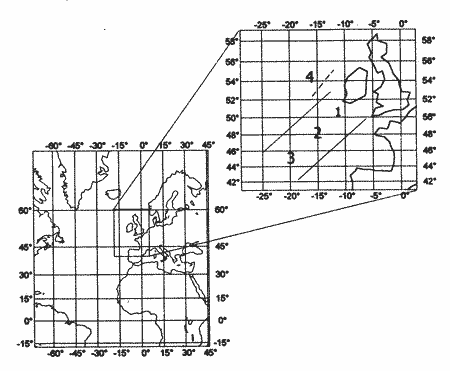 |
Figure 1. Location and boundaries of the scientific reserve "European
deep-water transect".
Numbers indicate long-term stations:
- "Deep-water Porcupine bay";
- "Porcupine abyss valley and a European Union long-term station";
- ''BIOTRANS" program station;
- "Roccall Bank".
The firm line shows the suggested reserve boundary, the dotted line shows
the transect in Roccall depression.
|
This European Deep-sea Transect USPA is one example for those areas in which
scientific investigations were concentrated over the last two decades. Other
such areas exist in the North Atlantic and the Pacific Oceans, and it is hoped
that legal and organizational conditions will be developed to establish USPAs
in the near future.
References
Laubier L., Monniot C. (eds.). Peuplements profond du Golfe de Gascogne.
Ч Camp. BIOGAS, Ins. Fran. de Recherche pour lСExploration de la Mer, 1985.
Ч 629 p.
Mauchline J. (ed.). The oceanography of the Rockall Channel. Ч Edinburgh,
1986. Ч 356 p. Ч [Proc. of the Roy. Soc. of Edinburgh; 88B].
Mittelstaedt E. (ed.). Ausbreitungsbedingungen fuer Stoffe in grossen
Ozeantiefen: Rep. Deutsch. Hydrograph. Inst. Ч 1986. Ч 202 S.
NRC. Deep seabed stable reference areas. Ч Wahington (DC): Ed. of Ocean Policy
Com., Nat. Res. Council and US Nat. Acad. of Sci., 1984. Ч 74 p.
Pfannkuch O., Hoppe H.-G., Thiel H, Weikert H. (eds). BIO-C-FLUX Ч
Biologischer Kohlenstoffluss in der bodennahen Wasserschicht des kuestenfernen
Ozeans. Ч Kiel: Ber. aus dem Inst. fuer Meereskunde an der Christian-Albrechts-Univ.
Kiel, 1995. Ч Bd. 280. Ч 114 S.
Rice A. L., Billett D. S. M., Thurston M. H., Lampitt R. L. The Institute
of Oceanographic Sciences biology programme in the Porcupine Seabight: background
and general introduction // J. of the Marine Biol. Ass. of the UK. Ч 1991.
Ч Vol. 71. Ч P. 281Ч310.
Thiel H., Angel M. V., Foell E. J., Rice A. L., Schriever G. Environmental
risks from large-scale ecological research in the deep sea. A desk study:
Contract ╣ MAS2-CT94-0086, Europ. Commis., Directorate Gen. for Sci. Res.
and Development, Marine Sci. and Technol. Ч 1998. Ч 210 p.
Thiel H., Pfannkuche O., Schriever G., Lochte K., Gooday A. J., Hemleben
Ch., Mantoura R. F. G. , Turley C. M., Patching J. W., Riemann F. Phytodetritus
on the deep-sea floor in a central oceanic region of the North-east Atlantic
// Biol. Oceanogr. Ч 1989. Ч Vol. 6. Ч P. 203Ч239.
Thiel H., Rice A. L. Structure and variability of the deep-sea benthos
Ч Results from EU funded research // Int. Rev. der Gesamten Hydrobiol. Ч 1995.
Ч T. 80. Ч S. 149Ч151.
<< | contents
| top | >>
|