The following examples of the need for, or the use of, GIS in coastal management are intended to illustrate the challenges and benefits of using GIS, and also how GIS can be implemented. At the end of each example are contact details if you wish to find out more about any of the examples.
Strymonikos and Ierissos Gulfs, Greece.
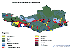
This example describes the study area as a complex multiple use zone, intensively used for tourism and natural resource exploitation. The area is also subject to uncontrolled development and deteriorating environmental conditions. This example illustrates the complexities of a real coastal zone and highlights the need for high quality geographic information in order to make sound management decisions. Srtymonikos example
Cavala Prefecture, Greece.
This example identifies the need to establish a Coastal Observatory to retain geographic data and to organise a coastal monitoring programme. This example also identifies clearly the need for adequate information management to inform coastal management decisions. Kavala example
Epirus, Greece.
In this example, "unorganised and dispersed" data is identified as a central problem in the implementation of a coastal management programme. The example describes a GIS and databank set up to address this need. Epirus example
Lochs Long, Duich and Alsh, Scotland.
This example describes the data management needs resulting from the implementation of the EU Habitats Directive and the need to identify Special Areas of Conservation. The role of GIS in the collection, management, analysis and presentation of relevant data is explained. Lochs Long, Duich Alsh example
Wadden Sea, Netherlands, Germany and Denmark
In this example, GIS is used to determine the
feasibility of the establishment of a Particularly Sensitive
Sea Area in the Wadden Sea. GIS is used to map environmental
values, maritime risk and, through spatial analysis,
identify potential PSSA boundaries. Wadden
Sea example
Black and Azov Seas
This example is taken from the Black Sea Environment
Programme to develop a spatial plan for the Black and
Azov Seas. It explains the context of the use of GIS,
the methodology used and a flow diagram displaying the
analytical procedures. Black
and Azov Seas example
|