APPROACH
The Black and Azov Sea coast are facing several problems. Some are caused by lack ownership and responsibility, others by lack of planning and by sectoral management. Spatial planning and functional zoning as step towards it can help to reduce the present conflicts in the coastal zone. The challenge of Spatial Planning is to select, in co-operation with the stakeholders, the best options for land use and prevent not wished developments. In this way it lays a basis for sustainable development and integrated coastal zone management. And it can be developed on local or regional level.
Spatial planning, the environmental and the social-economic situation are closely connected to each another. The quality and use of the natural resources is the main source of economy. It may be in the form of drinking water and save beaches for tourism or quality of soil for agriculture or generally health of local people. Beside that ecological conflict are often linked to social-economic conflicts. Functional zoning can help to reduce these ecological and inter-sectoral conflicts.
The functional zoning is step towards spatial planning, serving the best options for land use, which meets the local needs and saving recourses for future. This is done to divide the are in different zones of development where the one zone is buffering the impact of the neighbouring zones on each another. By this planning wished development can be stimulated and unwanted prevented.
First step in Spatial Planning is political and administrative preparation and public involvement to decide the goals and objectives and to organise the involvement of all stakeholders. First than the actual work on planning can start like inventory, analyses and functional zoning like described below.
Spatial Planning should cover a period of at least 5 years is that for effective social-economic and ecological development a long term stable policy is essential. The longer the stable policy and strict implementation will last the higher the impact of the proposed policy. Better a longer stable and clear policy, which is not ideal than a left and right moving initiative taking advantage of the moment.
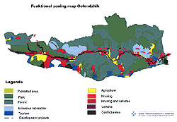
Click
to enlarge
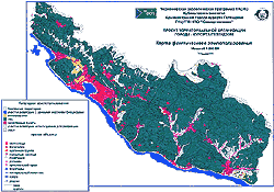
Click
to enlarge
MAPPING AND GIS
A key factor in Spatial Planning is the presentation of the complex information and restrictions in such a way that administration and public can understand and handle them. This needs special techniques. Mapping is a major one by Spatial Planning. They are a vital source of information for short term and long term planning. It offers an understandable view on development and character and relations in the landscape. It helps calculating value of regions and impact of human activities. It gives an overview of human use and facilitates analysis by overlaying of maps. Photographs and maps are easily read and interpreted and transcend language and cultural barriers to communication and analysis.
Types of information that have been found to be the most useful include basic topographic maps in a scale of preferable 1:50,000 or larger, with a minimum of scale of 100.000. The single most important map parameter is topography using appropriate elevation contour intervals with a minimum of 200 meter. In addition to topographical maps spatial or arial picture of similar scale with a resolution of 5 meter are very useful for abiotic and biotic information.
The result of mapping is a graphic representation of the type, area, and location of impact. It permits a better than educated guess about the value and sensitivity of the natural components, the intensity and risk of impact that may occur. It does not make the final decision but provides additional information in a readily understood medium so that the decision can be made with a greater degree of confidence.
To enable combining data and maps, combining and comparing of the mapping the use of a Geographical Information System is indispensable. This computerised system enables to link data of all different kinds to areas, lines and points on maps. Even more important it enables the combining or comparing of maps and producing new maps. For example flora and fauna maps can be compared to identify the relation between the presence of flora and their related fauna. At the same time a new map can be produced which shows the combined value of flora and fauna. Another possibility is the comparison of land use and the ecological value and sensitivity of a region to identify possible conflicts of interests.
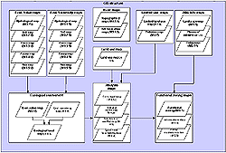
Depending of the use the maps can be produced in different scales. In practice the maximum details are shown at 1:50.000 as this is the level of the source maps. The following scheme shows the structure of the proposed GIS system and available outputs
To combine 2 maps an intermediary map, which shows the combination of values is produced. The second output is a table showing all on the map present combinations of values. All these combinations should be given a new value according to the agreed system, after which the final map will be shown. The final map will show only the last values. In this way not only common values can be identified but conflicts, too. Therefore GIS will be of great help by the analysis of conflicts. GIS enables combining a variety of maps, as discussed later, and by editing the table with different values different levels of conflict can be analysed.
While the borders of object are not fully overlapping each another harmonisation of maps will be needed to eliminate too small areas and to add them to the most sensible neighbouring areas. Another possibility is to correct the insecurities in borders of the source maps.
Preferably the data centrally stored, managed and data be added or changed. The access for viewing the GIS information should be as wide as possible e.g. through spreading of CD-ROMs or by access through Internet.
Click
to enlarge
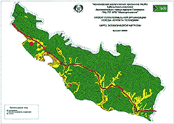
Click
to enlarge