The Wadden Sea provides an important route for shipping, particularly to the main German ports, however, the inter-tidal nature of the Wadden Sea coast is also very sensitive to marine pollution. Environmental Protection is perceived as a trilateral responsibility, therefore the possibility of seeking Particularly Sensitive Sea Area (PSSA) status for the Wadden Sea was investigated. PSSA status is awarded by the International Maritime Organisation (IMO) to areas that meet certain environmental, social and scientific criteria. If designated, shipping may be required to adopt practices intended to provide enhanced protection from marine pollution.
A feasibility study was undertaken using GIS to establish the location of areas fo high environmental value and areas of potential maritime risk. From the results of this, suggestions could be made for the delimitation of a Wadden Sea PSSA.
Click
to enlarge
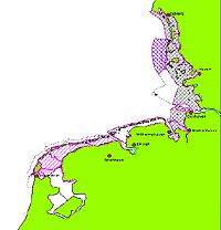
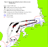
The maps below shows areas of current vulnerability (environmental significance) and areas in which maritime activities take place (potential hazards). Through combining these maps, it was possible to determine potential boundaries for a PSSA to relate to the areas most at risk and those areas posing the greatest risk.
Based on this study, Ministers at the 9th Trilateral Wadden Sea Conference decided to submit a joint proposal to IMO for the establishment of a Wadden Sea PSSA. Further information about the Wadden Sea Proposed PSSA and a full copy of the feasibility study can be downloaded from http://cwss.www.de/tgc/pssa/pssa.html
Click to enlarge