|
You are here: /
Practice / Planning
Purpose and stages
The purpose of the planning stage is to identify and support
a proposal to decision makers to establish continuous
and integrated management of the coastal and marine area.
Three substages are identified: data collection, policy
development and decision making.
Data collection
First, a coastal profile must be prepared. This
is an overview of all (natural, social, engineering, institutional
and management) characteristics relevant for the problems
at hand for the given area. The World Bank (93)
gives the following list of items that should be covered:
- Coastal Resource Base
- Social Organization in the Coastal Zone
- Existing Environment and Resource-Related Programs
- Institutional. Legal, and Financial Capacity
The coastal profile leads to a detailed formulation
of the problems and the information gaps that still
need to be filled.
|
The Kastela Bay Coastal Profile
Natural characteristics: The Kastela Bay is located
at the central part of the Croatian coast on the eastern
part of the Adriatic Sea. The area encompasses the Kastela
Bay and the neighbouring Split and Brac Channels, as well
as the associated coastal strip. The coastal plain around
the bay is 1-3 km wide covering approximately 14,500 hectares.
Socio-economic conditions: The total population
of the narrow coastal area has tripled over the past
half a century, reaching 284,000 inhabitants in the
year 1991, while the estimated population for the year
2015 will be 355,000. Split is the second largest town
of Croatia.
Institutions and management: Ministry of Environmental
Protection and Physical Planning is the supreme administrative
body in charge of the organization of environmental
protection and sustainable development in the Republic
of Croatia. It prepares the laws related to environmental
protection, monitoring and the state of environment.
|
Policy Development
Second, based on the profile, a policy must be developed
which is the core of the ICZM process written down in
the ICZM program. This document gives:
- the precise definition of the area considered:
the coastal zone. Such a boundary may be based on
physical
processes, biological
processes or on existing legal
frameworks,
- the goals of the ICZM program: A good management
program has well defined goals to prevent it loosing
its impulse,
- the strategies: The goals should be accompanied
with several alternative policies which are evaluated
with respect to their success of attaining the goals
(see also the Policy Analysis module),
- a description of the proposed institutional arrangements,
including assignment of responsibility for various
parts of the programs,
- funding and staff requirements, and
- a list of the formal actions necessary for official
adoption of the plan and a suggested timetable for
completing these.
Decision Making
Finally, the ICZM program must be accepted by the decision-makers
and formally adopted. Chances of timely approval are increased
if the program (cici98)
- uses clear and understandable terms
- describes the benefits in tangible and meaningful
terms
- is endorsed by all stakeholders
- is known to key politicians which have received
regular updates on the ongoing process of its formulation
- illustrates the involved costs and ways to cover
them.
|
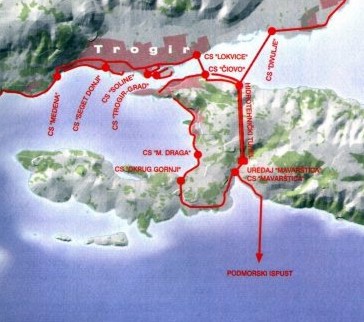 Long-term solution of the sewerage system in the
Kastela Bay. The map shows the area around Trogir.
Long-term solution of the sewerage system in the
Kastela Bay. The map shows the area around Trogir.
The long-term solution of the sewerage system, developed
on the basis of a detailed analysis of ecological, technical
and economic parameters, envisages the construction
of two separate sewerage systems, one for the Split
- Solin area and a separate one for the Kastela - Trogir
area. Each system is of a separate sewerage type, consisting
of a sewerage network, collectors and pump stations,
a central waste water treatment plant, and a corresponding
submarine outfall.
|
General objectives of
the National Project “Environmental Management of the
Kastela Bay” were, by application of scientific methods,
to:
- identify the causes of the present situation and
trends;
- assess their impacts and significance; and
- develop alternatives for sustainable development.
Specific project objectives were as follows:
- to define the sensitivity, vulnerability and (limited)
carrying capacity of the natural resources;
- to introduce standard procedures and parameters
in the process of management of natural resources;
and
- to apply, within the project scientific framework,
an integrated approach and principles of sustainable
development.
The area of Kastela Bay is under administration of four
municipalities, province and relevant ministries. For
the purpose of the Integrated Ecological Project, ECO-Kastela
Bay agency was founded by the 4 municipalities and the
Government of Croatia through the relevant institutions.
The main task of the Agency is, on behalf of its founders,
to prepare and implement the agreed projects of common
interest. The Agency represents its founders in front
of investors and banks, and implements the project according
to the conditions posed by the creditors and the founders. |
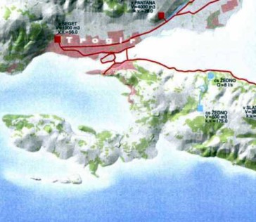 The envisaged water supply system.The map shows the
area around Trogir.
The envisaged water supply system.The map shows the
area around Trogir. The water supply project envisages additions to and
spreading of the existing water supply system which
includes the construction of a central pumping station,
four smaller regional pumping stations, 17.5 km of water
supply pipelines, and four reservoirs of various capacities,
as well as an appropriate management system.
|

|
|