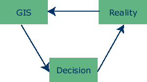
It is important to recognise that GIS are only one component of a decision-making loop. The loop has 3 main components:
1. Reality
This is the situation that requires improved management. It may be an estuary, beach or other coastal unit. A simplified version of reality can be established through the collection of data. The data needs to have a spatial and attribute components. Together, these components allow the GIS user to determine 'what' happens 'where'. It is important that the data collected accurately reflects reality. Deciding upon data sources and ensuring the collected is of high quality are therefore both very important.
2. GIS
Once the data has been collected, it is entered into the GIS. The GIS therefore contains data layers, which together represent a model of reality. The layers can be overlaid or combined to identify geographic patterns and relationships. Furthermore, because the data is stored in a database, the data can also be used for statistical and other numeric analysis.
There are several methods of data input, each of which can affect data quality and data format. Data can be stored in the GIS database in raster or vector format. The format of data can also influence data quality.