Two rivers flow into the Bay Teluk near Portharbor: Kali Migraine and Rio Pusing. Kali Migraine carries agricultural run-off (mainly nutrients, phosphates from fertilizers) from the rice fields upstream. Also a tin mine is located upstream, which is an important industry in the region. The tin-ore (cassiterite) is dredged from the flood plain of the river. The tailings of the mine are also flushed in the Kali Migraine. Rio Pusing does contain less pollutants.
The city of Portharbor is located along the Bay Teluk, and includes industrial activities and port facilities. Here, oil from shipping, household waste from a municipal waste water treatment plant and industrial effluent enter the bay. Some traditional fishing takes place just beyond the spit Sandy Point. A 9 km stretch of undeveloped shore line lies on the eastward side of Bay Teluk, and beyond that a slightly sheltered bay, with significant coral reef communities. The clear waters and coral reefs in the Pesisir Tropicana Region are ideal for bathers and skin divers.
The area around Lilly Town is mainly in agricultural use. In the polder-island, north of Lilly Town there is intensive rice production. The island opposite Portharbor is mainly used for grazing cattle; it is rather peaty over there. The right bank of the Kali Migraine is urbanized. In the non-buildup areas there are many scattered buildings, small industry, etc. The area just east of Portharbor is mainly used for horticulture.
Because of the high river runoff, the western part of the estuary has a very low salinity. In fact the saline water does not enter the rivers, and stays into the basin of Bay Teluk. Only during the dry period, some increase in salinity can be observed in the first 5 km of the rivers, causing some problems with the irrigation intake structures in the lower section of the river.
The
water of the Kali Migraine is hardly used for irrigation of the rice-paddies
around Lilly Town, because of the high contents of solids due to the mining
activities. So, nearly all irrigation water comes from the Rio Pusing.
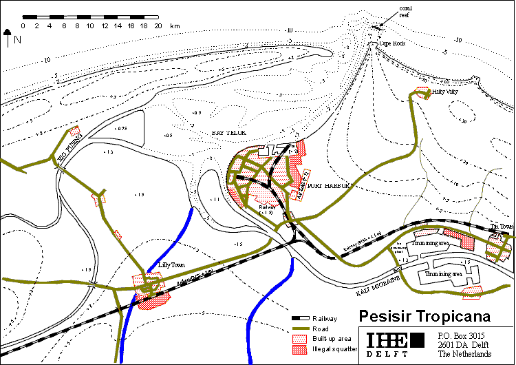
| The catchment area of the
Rio Pusing is rather small, in the order of 1600 km2. The rainfall
in this area is given in the following figure.
This results in a discharge curve of the Rio Pusing with an average discharge of 95 m3/s in week 1 to 19, a discharge of 14 m3/s in week 20 - 37, and a discharge of 80 m3/s in week 38 - 52. The average discharge is 63 m3/s. Just outside the map of the area, a dam is under construction; this dam has a head-difference of approx. 30 metres. The installed power of the hydro-turbines is 25,000 kW; however it is assumed that this dam will not be used at full power. A constant average output of 15,000 kW is expected. |
 |
During
50% of the year winds come from southerly directions, southern winds are never
strong. During 30% of the year, winds come from north-westerly directions, creating
a wave height of approximately 1 m. During 10% of the year (35 days), winds
come from northern directions, creating a wave height of approximately 3 m.
However, this occurs only during the three months of the stormy season.
The wind speed exceedances, in occurrence per year, as function of the
direction is given in the Table 1:
Table
1 Wind speed exceedances
| Direction | 15 m/s | 20 m/s |
| W NW N NE E |
0.03 0.04 0.07 0.06 0.02 |
0.0006 0.0015 0.009 0.005 0.002 |
Sometimes tropical storms can create strong winds from easterly and north-easterly directions. The frequency of these tropical storms is relatively low, but most people remember the disastrous storm of 15 years ago, when the sea flooded most of the urban area.
The
sea north of Pesisir Tropicana can be considered a relatively shallow sea, with
a average depth of 10 - 20 metres over a distance of 50 km. At this point is
the edge of the continental shelf, and the bottom drops to -100 m. The next
shoreline is 700 km away.
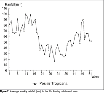
| Tin mining
The tin-mining activities are located in the floodplain of Kali Migraine. The produced cassiterite is transported overland to the commercial port of Portharbor. The annual output is one million tons, representing 100 MUlc. This sector employs 15,000 people in the region. There is currently no on-site treatment of cassiterite at the mine. |
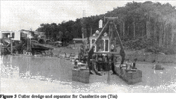 |
| Agriculture
Agriculture is mostly concentrated in the watershed of the Rio Pusing. The agricultural activities include rice cultivation and animal husbandry, mostly for local consumption. The economic value amounts 55 MUlc. There is a very limited potential for increasing the area for agricultural production. Agricultural run-off goes to the Rio Pusing, which flows into Bay Teluk. The water of the Rio Pusing is used for irrigation in the area north of Lilly Town. This area is 512 km2, but only 90 % is real irrigated rice paddy (450 km2). At this moment only one crop per year is produced, but after completion of the dam, double cropping will be introduced. |
 |
| The water demand of this area is determined using the method worked out by Thoradeniya (1995). In the following figure the demand per week is given as function of time. Given are the periods in which the given value is needed. The total demand of water over the year is 949 mm/year, which corresponds to an average required discharge of 14 m3/s. | 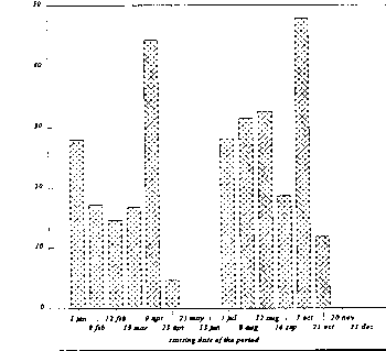 |
| Fisheries
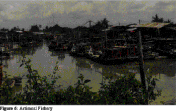
Fisheries in the Pesisir Tropicana Region is mostly traditional and practised on a limited scale around the small coral reefs, bars and islands (cays), which are scattered in the entrance of Bay Teluk. Some fishermen use dynamite, which officially is forbidden. However, it can be practised, as there is a weak law-enforcement. There are no fishing activities in Bay Teluk itself. The current annual output in the fisheries sector is 10,000 tons of fish, representing 30 MUlc, all of which is used for local consumption. Approximately 30,000 people are involved in fishing, using 6000 boats. Presently, aquaculture is practised on a very limited scale, and has no significant economic value. |
 |
Tourism
Portharbor has a number of hotels, mainly used by the business community and some local tourists. They contribute to the regional economy with 15 MUlc annually. The residuals generated by these hotels are considered as part of the household wastes, and can not be distinguished from these.
Other sectors
The other sectors are, economically speaking, relatively small when compared to the above mentioned ones. They refer to building, general industry, retail and services, etc. The total number of jobs, as well as the income and pollution generated by the other sectors are a approx. 50 % of the sum of the activities in the designated sectors (agriculture, mining, fisheries and tourism).
 Urban
area
Urban
area
The activities in the urban area are not singled out to one sector, but divided over some of the above sectors. However, the development options are strongly influenced by the developments of the city. Out of the total population of 600,000 in the Pesisir Tropicana Region, approximately 300,000 live in Portharbor, which covers only an area of 20 km2. In the recent past, there was a high influx of rural people towards Portharbor, which resulted in non-regulated urbanization in the outskirts of the city, especially on the floodplain of Kali Migraine and on part of the coastal area.
The availability of skilled labour is estimated at 40% of the projected population growth rate.
Storm water run-off and 60 % of the household waste water discharges by drains and canals to a waste water treatment plant, where it is treated before being discharged into Bay Teluk. The remaining 40 % is discharged directly into the Bay.