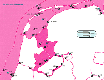
GIS project management
In order to increase the probability of successfully implementing GIS for a specific project, a strategy should be developed which takes account of all elements of the decision loop in order that data quality is maintained and decision quality optimised.
A typical GIS project management progression might be as follows:
1. Determine the aim of the study
- Define the required outcome of the project
- must be stated clearly
- eg. to identify an area suitable for the deep sea disposal of offshore structures.
2. Identify data needs
- construct model of reality
- Need appropriate data to make an informed and strategic decision
- Define parameters
3. Prepare a plan of GIS use (sometimes called a Cartographic Model)
- This is a flow diagram charting the datasets to be used and the analytical techniques to be applied. This is as important for quality assurance as it provides a record of what analysis was undertaken
- Prepare a GIS project log
4. Assemble the required data
- This may include a combination of:
But important considerations are
- the quality of the data - is it appropriate to the study?
- data management -management is needed to maintain data quality
- time
- money
- context of study
5. Enter the data into the GIS
- choose data entry method
- data sensitivity analysis - consider impact of data quality in final result
6. Interrogate the GIS
- minimise impact of data error on project
- fuzzy or boolean
- query system to gain output
7. Make decision
- system identifies potential sites
- decision based on other factors also
- value judgments
- role of GIS to aid decision making
In summary, it is important that data quality is appropriate to the level of the decision being made. If data quality is too low, the decision will be sub-optimal. At each stage in a GIS project there is scope to weaken data quality, therefore the project must be carefully managed to maintain appropriate data quality. In coastal zones, because the elements being mapped may be more complex, the importance of data quality is likely to be enhanced.
Software and Hardware required
Finally, it is important to consider the practicalities of setting up a GIS. Today, GIS software packages can be bough 'off the shelf'. These are empty of data, but otherwise ready to use. Once you have entered the data you require, they can begin to help you make better decisions. To run modern GIS packages requires relatively little specialist equipment to gain immediate benefit from its use. The major expense and most important requirement is a good standard personal computer. The two main considerations to make with regard to the specification of the computer are memory capacity and processing speed. The larger the memory, the more data it can hold, and shorter processing times reduce analysis time. A good quality printer can provide professional output.
Essential:
- personal computer
- printer
- Back up data storage system
May be required:
- Scanner
- Digitizer
- Large paper size printer
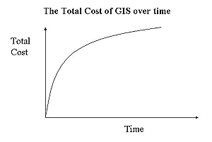
The cost of setting up GIS will vary according to the hardware needed, software chosen, and expense of data collection and entry. It is therefore very difficult to estimate a cost. General advice is that the larger the project (large numbers of datasets, complex analysis, etc), the higher the specification of equipment that will be required. For smaller scale projects, a standard desktop PC, printer and scanner will be fine. GIS can therefore offer a relatively cost efficient way of improving decision-making. It is important to note that the cost of establishing GIS is front loaded, with investment required at the outset. However, once the initial expenses have been met, expenditure is relatively small. |